Watch FarrPoint's new video which explains how the mapper works and details the benefits it can provide.
Our mobile coverage mapper is an autonomous network monitoring tool that provides real-life performance statistics of all available mobile networks. The Mapper comprises a small unit with antennas. The unit can be fitted into any vehicle and will measure the signal strength of all mobile networks simultaneously as it travels the route of interest. The device sends the performance data back to our processing and mapping servers, enabling a true picture of mobile network performance.
Our Mapper has already been deployed across a number of council areas in the UK (North Wales, Newcastle, Shetland, Worthing, Horsham and Chichester) and internationally (New Brunswick, Nova Scotia), providing the most accurate information on mobile connectivity. Most of our clients chose to deploy the mapper on their refuse vehicles, which is a great, cost-effective and more environmentally friendly solution. Although the mapper can be installed in any vehicle or even operated on foot with our backpack version.
• Significantly lower costs than standard drive test surveying, which requires specialised resources and equipment
• Collected data identifies mobile ‘notspots’ or weak 4G / 5G coverage, which can be used to feedback to mobile network operators for future mobile planning
• Provides independent coverage assurance and verification – especially important for organisations running mission-critical communications over mobile networks (emergency services, telecare)
• Our mapper device is autonomous, installed easily to any vehicle and requires no technical knowledge.
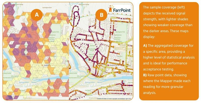
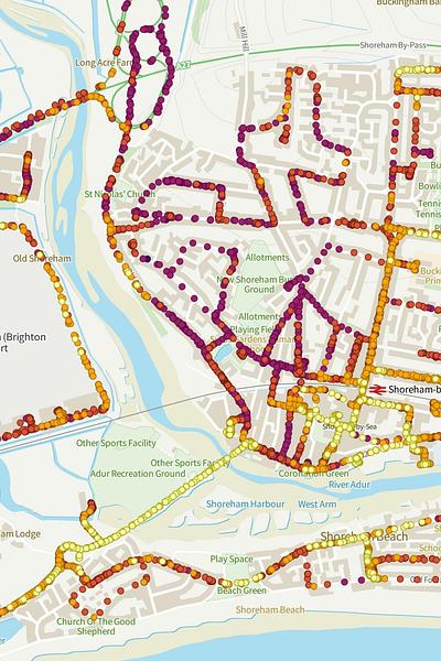
Image 1: Mobile Coverage map example
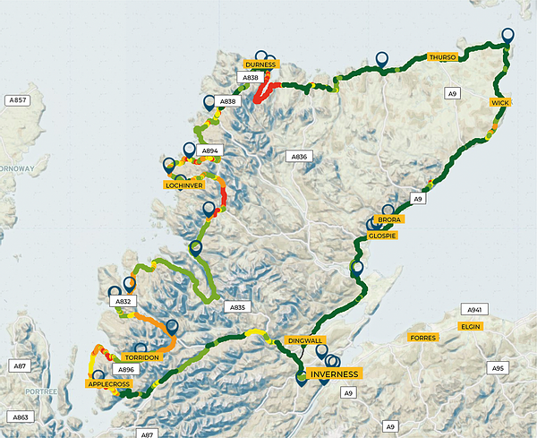
Image 2: NC500 4G coverage map for all UK operator
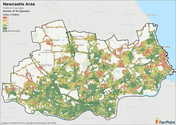
image 3: Newcastle and North Tyneside indoor mobile coverage map
• Independent & real-time monitoring of 3G/4G network performance in outdoor areas
• Our Mobile Coverage Mapper is autonomous, installed easily to any vehicle and requires no technical knowledge
• Logs multiple engineering parameters, including signal strength, channel parameters and location data
• Results and analysis are stored in a secure central database and presented on a secure mapping portal in real-time
• Survey results are presented in a simple visual format. No technical knowledge required to interpret results
• Scalable design - multiple units can be deployed across areas, simultaneously collecting data to continuously build up a library of mobile network measurements across a geography
If you'd like to know more about our mobile coverage checker, please get in touch.
“We want Newcastle to be the best connected city that it can be and we know that has become even more important with the growth in working from home. This exercise has given us the real experience of residents, businesses and visitors, which in some cases is different to the data published by networks, and with this street level detail we can look to work with mobile providers to improve coverage and hopefully rid our city of “not spots.”
Jenny Nelson, Digital Newcastle Programme ManagerConnectivity is important. It drives business and society, bringing communities and commerce together. That's why we use our insight and experience to connect people and business.